Run Example6_Final with Chama
Initial exploration
- The Example6_Final file that is used in the swmopt2 is the gold standard but it is not called Example6_Final it is called Gold Standard. Some of the inital work was done with this file but most was done with a file actually named Example6_Final.
- I will be using the gold standard we use for OSTRICH from the Examples folder in the Ostrich Django program as a starting point.
- There will be changes made to the file.
- How pollutant is added.
- Number of rain gages.
- I am making folders for 2022 in the chama folders all runs that are from this new iteration are being put in these folders both Example_6Final and Banklick.
- There are 2 rain gages being ued in Example6_Final gold standard raingage and null.
- Several runs have been made with a Single Rain gage (Eliminated Null and are only using the rain gage raingage)
- Rain gage data can be defined in 2 ways in a rainfall.dat file or in [TIMESERIES] section of an INP file.
- Example6_Final and Banklick both only use the [TIMESERIES] data.
- The [TIMESERIES] for a rain gage is set in the Raingage section of the inp file.
- There are several additional Rain gage [TIMESERIES] data in Example6_Final.
- 0.1-in
- 0.23-in
- 2-yr
- 10-yr
- 100-yr
- All the junctions are currently being used as possible sensor locations in Example6_Final.
For more Information about the initial Exploration of chama for this phase please review that Initial Run notes using Example6_Final.md
Current Path
While witting the QAPP a list of Scenarios were decided on the table can be viewed in the Chama Overview. As part of this effort several runs have been formulated. This is the current formulation of the Example6_Final Chama effort.
Rain Gages
Single Rain gage
In the Example6_final 2 rain gages are used 'raingage' and null the 'raingage' has rainfall data and the null does not have any rainfall data. This has not changed. Although as stated above in the initial phase multiple single rain gage runs have been made with different time-series rain events being set to the 'raingage'.
Mublitble Rain Gages
Important Information for this section
- Rain gages are assigned in an INP file at the Subcatchment Level.
- There are Subcatchments in Example6_Final.
- Due to the low number of subcatchments it is easy to eyeball a section and give it an addtional rain gage.
Plumes
- Plumes are how we are adding in the pollutant to the simulation.
- Currently Plumes are being added into the simulation at a subcatchment level using Loadings section of the INP file.
- This seams to be the lowest granularity that a plume can be added.
- For more information on Pollutants See the Pollutant modeling md file.
- Again EPA SWMM UI was used to view the network and decide on plumes loacations of the plumes.
- Since we want single and multiple plumes I created 2 plumnes for this example.
Sensor Locations
- The number of possible sensor locations does effect the amount of time it takes to run generate chama inputs.
- At _ locations with Example6_Final it takes min.
- Currently sensor locations are being placed on the Outlet on every junction.
- According to SWMM Documentation an Outfalls are terminal nodes of the drainage system used to define final downstream boundaries under Dynamic Wave flow routing. For other types of flow routing they behave as a junction. Only a single link can be connected to an outfall node, and the option exists to have the outfall discharge onto a subcatchment's surface.
- Given the definition of an outfall a logical place to put a sensor should be at the outlet of a subcatchment near the outfall as this is a location that should have a good amount of coverage.
- Given that this is such a small network sensor placement was not really factored in in a larger network we would look at the following:
- Only look at sensor locations as the outlet of the subcatchment.
- Higher prefrence would be for sensors to be placed near the outfalls of a simulation.
- Another factor in making a sensor location more likely would be if multiple subcatchments feed into a single outlet.
- Also check to see if there is a way in SWMM to see how much water goes through a specific outlet. In example_6 final there are obvious junctions that are good spots to put sensors on because a lot of water is combined from branches of the network into these locations. They are sort of center junctions. I know I am not using the right terminology here but multiple branches of the network are combine down into fewer links.
Current Status
- The Example6_Final inp files have all been created.
- The Python file Generate Chama Inputs has been run on all inp files so we have signal files for each inp file.
- Chama Runs for Scenario 1, 4, 7, 10, 13, 14, 15, and 16 have been run but are not yet committed.
- I am currently making changes to python file Chama_opt.
- I am also moving everything into the Chama 2022 repo. I will be re-running the scenarios that have already been run.
- I am going to look at the sensors locations.
- Land sensor locations are likely to be at the subcatchment level not the junction level.
- This is because we are measuring the buildup at the subcatchment.
- Land sensor locations are likely to be at the subcatchment level not the junction level.
- I am working on the Land and pipe damages.
- I think I need more scenarios. The gold standard only had 1.
- I am also looking into how to find the impact_cost. It looks familiar but I do not think I am generating it currently.
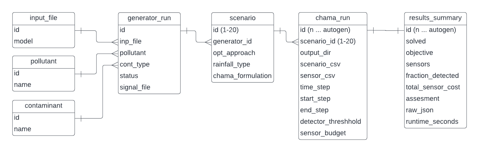
- Sudhir requested to go over the Database with Jake. That has been done.
Current Results
This is a list of the current scenarios that need to be run for Example6_Final. The scenarios refer to the Chama Overview table.
- Scenario 1
- Scenario 2
- Scenario 3
- Scenario 4
- Scenario 5
- Scenario 6
- Scenario 7
- Scenario 8
- Scenario 9
- Scenario 10
- Scenario 11
- Scenario 12
- Scenario 13
- Scenario 14
- Scenario 15
- Scenario 16
- Scenario 17
- Scenario 18
- Scenario 19
- Scenario 20